ENTWURF / DRAFT:
_File: “Overlay_geograf.Einheiten_zur_Germania Magna Neuinterpretation nach Sven Mildner.kml”:
Erster Entwurf eines Kartenoverlays mit den geografischen Einheiten der Germania Magna, übertragen auf die Bundesrepublik Deutschland bzw. auf ein modernes WGS84-Koordinatensystem für Google Earth
First draft of a map overlay featuring the geographical units of Germania Magna, adapted to the area of the Federal Republic of Germany and represented in a modern WGS84 coordinate system for Google Earth
++++ ENTWURF ++++ DRAFT ++++ ENTWURF ++++ DRAFT ++++
▶ Kartenoverlay direkt in Google Maps öffnen
oder
▶ Download KML/KMZ (für Google Earth)
++++ ENTWURF ++++ DRAFT ++++ ENTWURF ++++ DRAFT ++++
aktuelle Version: Beta-23b vom 30.05.2026


Hinweise zur Version 3 vom 01.05.2025:
- Verbesserte Ausrichtung von Albis Fluvius im Bereich der mittleren Elbe, süd-östlich von Magdeburg
- des Unterlaufes bzw. des Mündungsbereiches von Rhenus Fluvius, enger angelehnt an die Kartenüberlagerung und nicht an den heutigen Verlauf des Rheins (siehe nachfolgende Grafik “Figure A”)
- Ergänzung des Overlays um den Fluss “Vidrus Fluvius“, entsprechend der Kartenüberlagerung, mit der Quelle beim Vogelsberg in Hessen (siehe nachfolgende Grafik “Figure A“)
Anmerkung: Der Quell- und Mündungsbereich des Visurgis Fluvius ist entsprechend der Kartenüberlagerung nach Norden verschoben worden, im Vergleich zur Originaldarstellung auf der mittelalterlichen Karte des Donnus Nikolaus Germanus.
English:
- Improved alignment of Albis Fluvius in the middle Elbe region, south-east of Magdeburg
- [Revised representation] of the lower course and/or the mouth region of Rhenus Fluvius, more closely aligned with the map overlay rather than the present-day course of the Rhine (see following graphic “Figure A”)
- Addition of the river “Vidrus Fluvius” to the overlay, corresponding to the map overlay, with its source near the Vogelsberg in Hesse (see following graphic “Figure A“)
Note: The source and mouth region of Visurgis Fluvius has been shifted northward according to the map overlay, compared to the original representation on the medieval map of Donnus Nikolaus Germanus.
Version 4 (07.05.2025) – Changelog:
- Improved alignment of Albis Fluvius “Variante B” in the middle Elbe region between Bitterfeld-Wolfen and Braunschweig/Celle, and Addition of “Variante C” in the middle Elbe region with Albis Fluvius corresponding with a part of modern river Mulde near Dessau (Sachsen-Anhalt)
- Addition of the river “Tibiseus Fluvius” to the overlay, modern Iser/Jizera (CZ)
- .kml-file for Download is now a Network-Link-KML
Version 5 (08.05.2025) – Changelog:
- Improved Alignment for Chalusus Flu. (now Havel) and Suebus Flu. (now Nuthe)
- Better alignment for Fläming Heath
- Addition of some ancient settlements to the overlay (Alisum, Amisia, Asciburgium, Budorigum, Budorgis,
Budoris, Calisia, Carrodunum, Limiosaleum, Lugidunum, Mediolanium, Nomisterium, Parienna, Stragona)
Version 6 (10.05.2025) – Changelog:
- Improved Alignment for Vistula Flu., Suebus Flu., Viadua Flu. and Chalasus Flu. (see following graphic “Figure B“)
- Addition of ancient settlements Colancorum, Lupfurdum, Mersovium and Susudata
- Addition of “Ziltendorfer Niederung“
- Some points of interesst now have additional informations in the description text for a better understanding
Version 7 (12.05.2025) – Changelog:
- With this version, several of the Germanic and Sarmatian tribes are now located on the map.
Version 8 (12.05.2025) – Changelog:
- Further information was added to the description, initially regarding the Sarmatian tribes.
Version 10 (15.09.2025) – Changelog:
- Further information was added to the description, initially regarding the Sarmatian tribes.
- Settlements and tribes with a possible Celtic name origin are now marked with a black symbol, Germanic tribes with a blue one, and Sarmatian tribes with a yellow one. (dt.: Siedlungen und Stämme mit einem möglichen keltischen Namensursprung werden nun durch ein schwarzes Symbol gekennzeichnet, germanische Stämme durch ein blaues und sarmatische Stämme durch ein gelbes Symbol)
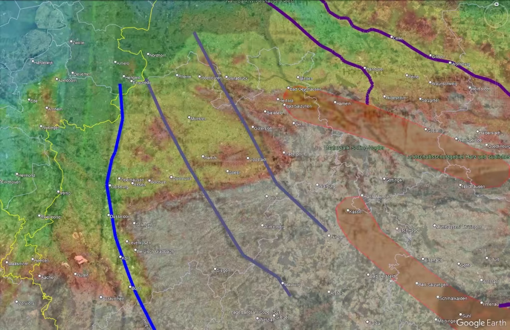
Figure A: The source and mouth region of Visurgis Fluvius has been shifted northward according to the map overlay, compared to the original representation on the medieval map of Donnus Nikolaus Germanus
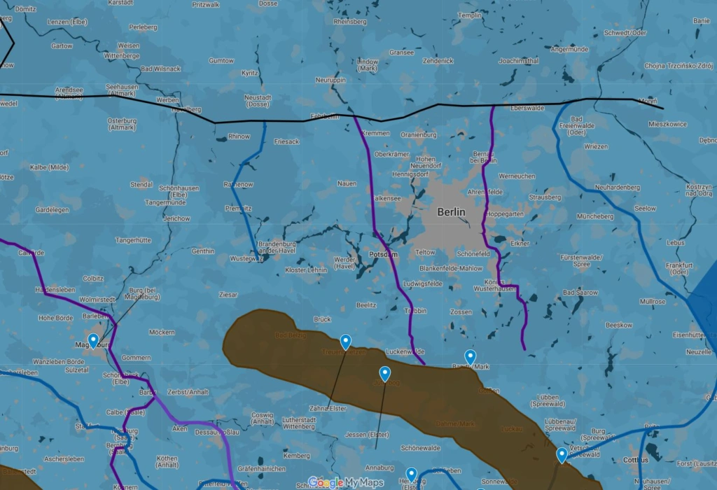
Figure B: Improved Alignment for Vistula Flu., Suebus Flu., Viadua Flu. and Chalasus Flu. in Version 6 of the draft for the KML Overlay.
The drawn course of the Chalasus Fluvius here roughly follows the Mercator map. According to the depiction of Germania Magna on the map by Donnus Nikolaus Germanus, the mouth area of the Chalusus Flu. is located approximately 15 kilometers further west, i.e., near Vehlgast/Kühlhausen or in the direction of Havelberg. This could indeed also indicate a change in the course of the river in antiquity, which becomes evident when comparing both maps and for which there are also further indications that such a change could actually have occurred. Consequently, it would then also be reasonable to assume that both maps might not depict Germania Magna at the same point in time, but that the course of the Chalusus Flu. on each map was recorded independently at different times. The question could still be whether a main channel was actually discernible in the mouth area here, or whether it was rather a branched delta. The course of the rivers drawn on the map, however, it seems, could also have been oriented much more directly along the course of the already existing subglacial meltwater channels. *)
*) Deutsch:
Der eingezeichnete Verlauf von Chalasus Fluvius orientiert sich hier grob an der Mercator-Karte (siehe oben). Nach der Darstellung der Germania Magna auf der Karte des Donnus Nikolaus Germanus ist der Mündungsbereich des Chalusus Flu. etwa 15 Kilometer weiter westlich, also bei Vehlgast/Kuhlhausen bzw. in Richtung Havelberg zu verorten. Dies könnte tatsächlich auch auf eine Veränderung des Flussverlaufes in der Antike hindeuten, der beim Vergleich beider Karten offensichtlich wird und wofür es auch weitere Indizien gibt, dass eine solche Veränderung tatsächlich stattgefunden haben könnte, Es wäre dann folglich auch anzunehmen, dass beide Karten womöglich nicht den gleichen Zeitpunkt der Germania Magna abbilden, sondern dass der Verlauf des Chalusus Flu. je nach Karte durchaus in unterschiedlicher Zeit und unabhängig voneinander erfasst worden ist. Die Frage könnte noch sein, ob hier im Mündungsbereich tatsächlich ein Hauptstrom auszumachen war, oder ob es sich vielmehr um ein verzweigtes Mündungsdelta gehandelt hat. Der Verlauf der auf der Karte eingezeichneten Flüsse, so scheint es, könnte sich jedoch auch vielmehr ganz direkt am Verlauf der bereits bestehenden subglazialen Schmelzwasserrinnen orientiert haben.
Version 12a/b (24.12.2025) – Changelog:
- rechnerische Bestätigung der Verortung des Römerlagers Aliso (bekannt durch die Beteiligung der hier stationierten Truppen an der Varusschlacht) bei Haltern am See, wie bereits durch andere Autoren beschrieben und durch die Bestimmung eines ptolemäischen Breitengrades (siehe hier).
mathematical verification of the location of the Roman camp Alisio (noted for its role in the Varus Battle) near Haltern am See by other authors, based on the calculation of Ptolemaic latitudinal distance (see here).
Version 14 (28.12.2025) – Changelog:
- more information about the identification of Dannubius Flu with modern Main and Eger Flu. and the rescaling factor for Germania Magna (relative to Gallia Belgica), see also https://www.germania-magna.de/rechnerische-bestaetigung-der-verortung-von-aliso-mit-haltern-am-see
Version 16/16b (01.02.2026) – Changelog:
- Addition of ancient settlement “Setuacotum” (am Glauberg, östlich des Taunus), sowie Riusiava, mglw. bei Kronberg im Taunus, bzw. Königstein im Taunus (vgl. hier zusätzlich auch Ringwall Altkönig und die Ergänzung zur rechnerischen Bestätigung der Verortung von Aliso mit Haltern am See)
Version 17/17b (29.03.2026) – Changelog:
- Nur kleine Veränderungen in der Beschreibung zum Stamm der Korkonti (südlich der Asciburgius mons)
- only small changes in the information about the Corconti (Korkontoi, griech. Κορκόντοι)