by Sven Mildner, 27.04.2025 ( Download as PDF ) ( German Version )
With the realignment of the Germania Magna map according to the Reinterpretation of Germania Magna (doi: 10.31223/X5313T), a new value for the length of a Ptolemaic degree simultaneously results.
The following explanation is therefore intended to provide a clearer understanding of the calculation method used to determine the correct value.
For the derivation, we first consider the two rivers that border Germania Magna to the east and west, for which Ptolemy recorded the coordinates of their estuary regions into the Oceanus Germanicus.
In the east, this is the Oder (Vistula Fluvius), with its estuary coordinates:
| the mouths of the Vistula river | 45*00 | 56°00 |
In the west, it is the Rhine (Rhenus Fluvius), for which three different coordinates are given. For the Germania Magna map, we select the centrally located estuary:
| Western mouth of the Rhine | 26*45 | 53°30 |
| Central mouth of the river | 27*00 | 53°10 |
| Eastern mouth of the river | 27*20 | 54°00 |
At the same time, we also consider another river to determine whether a longitudinal degree is uniform across the entire extent of Germania Magna — that is, whether it has the same value everywhere or whether distortions might exist, suggesting, for example, that the eastern part of the map could have a different scale, or that the map depiction might have been compressed or stretched.
For this purpose, the estuary of the Albis Fluvius is suitable:
| The mouths of the Albis river | 31*00 | 56°15 |
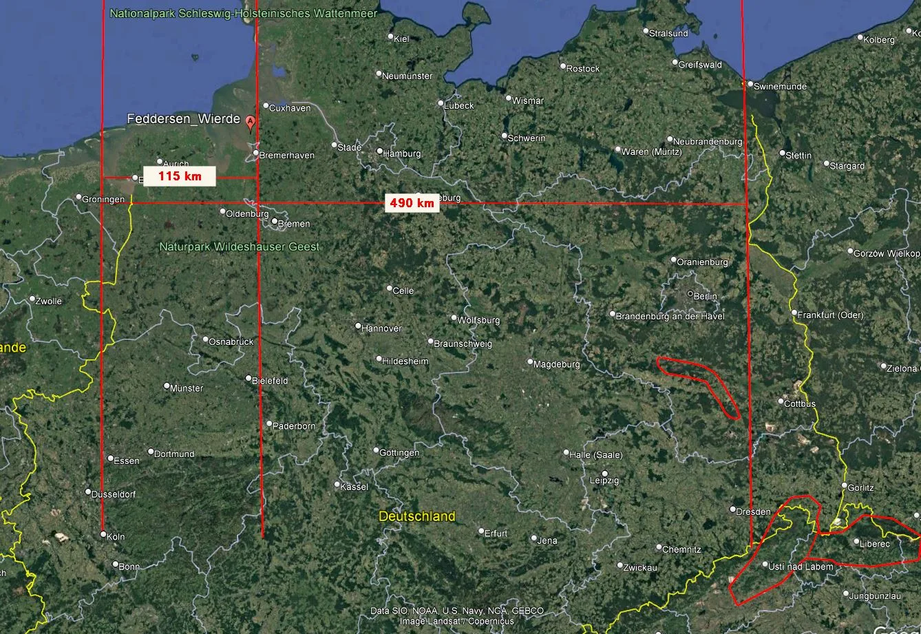
To better illustrate the context, the following maps are roughly aligned vertically, and the corresponding longitudes are drawn (see below), along with the measured distances:
- between Rhenus Fluvius and Albis Fluvius approximately 115 kilometers, and
- between Rhenus Fluvius and Vistula Fluvius approximately 490 kilometers.
▶ Rhenus-Fluvius (27°) – Albis Fluvius (31°):
31°-27° = 4° (≙ 115 kilometers)
1° ≙ 115km/4° ≈ 28.75 kilometers per Ptolemaic degree
and between:
▶ Rhenus-Fluvius (27°) – Vistula Fluvius (45°):
45°-27° = 18° ≙ 490 Kilometer
1°≙ 490km/18° ≈ 27 kilometers per Ptolemaic degree
▶ One Ptolemaic degree is approximately 28 kilometers wide,
consistent across the entire east-west extent of Germania Magna.
If the map had been composed of different sections with varying scales, or if there were significant gaps caused by merging various segments, one would expect much greater discrepancies between the two derived values.
Reverse Calculation:
(31° – 27°) × 28 km = 112 kilometers (longitudinal distance between the Rhine and Albis Fluvius estuaries, measured along the parallel; actual geographic distance is slightly greater due to differences in latitude)
(45° – 27°) × 28 km = 504 kilometers (longitudinal distance between the Rhine and Vistula Fluvius estuaries, measured along the parallel; actual geographic distance is greater due to differences in latitude)
Thus, the longitudinal degrees for Germania Magna can be relatively easily recalculated and translated into a modern coordinate system.
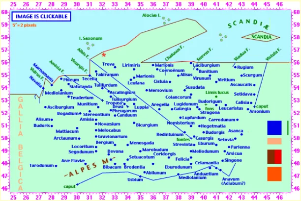

Image Credit for the “Schematic map of ancient Germany according to Ptolemy”:
The Geography of Claudius Ptolemy – © William P. Thayer
Download: