© Roman Eisele / Wikimedia Commons / CC BY-SA 4.0
.

On this page, you will find a collection of links to scientific publications that are relevant to this project or that can contribute to a deeper exemplary understanding of the processes and circumstances that may be related to the Reinterpretation of Germania Magna presented here. These publications span different research areas.

The collection includes:

  • Primary literature: Scientific publications presenting the results of new research.
  • Secondary literature: Scientific publications summarizing, analyzing, or interpreting primary literature.
  • Comparative literature: Publications that exemplify similar processes and circumstances in other contexts.
  • Additional resources: Links to websites, databases, and other resources that may be relevant to the reinterpretation

The following publications are intended to help answer specific questions exemplarily, which may be related to the necessary processes and events required for extensive landscape transformation. These include considerations of tectonic fracture events and rift systems, with corresponding effects on maritime landslide events and the formation of new sedimentation basins.


On Determining the Length of a Ptolemaic Degree in Germania Magna


Bestimmung der Länge eines Ptolemäus Grades - Die Neuinterpretation der Germania Magna durch Sven Mildner

27.04.2025 – On Determining the Length of a Ptolemaic Degree – Supplement to the Reinterpretation of Germania Magna (doi: 10.31223/X5313T) The realignment of the Germania Magna map according to this interpretation results in a new value for the length of a Ptolemaic degree. The following explanation is intended to make the calculation steps leading to this value easier to understand. For the derivation, we first consider the two rivers that border Germania Magna to the east and west, for which Ptolemy recorded the coordinates of their estuaries into the Oceanus Germanicus.

Additional Notes on the Geography of Germania Magna


Sven Mildner - Neuinterpretation der Germania Magna des Claudius Ptolemy - EVROPA TABVLA QVARTA – Quarta Europe Tabula continet Germaniam cum insulis sibi adiacentibus. Die Karte zu ''Magna Germania'' aus der im Original griechisch verfassten ''Geographike Hyphegesis'' des in Alexandria wirkenden Claudius Ptolemaios

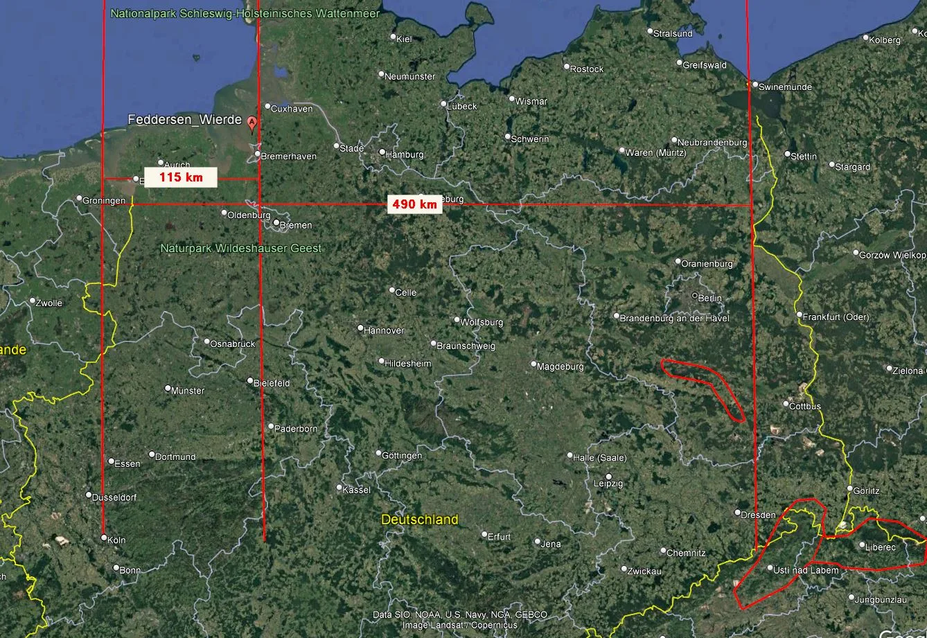
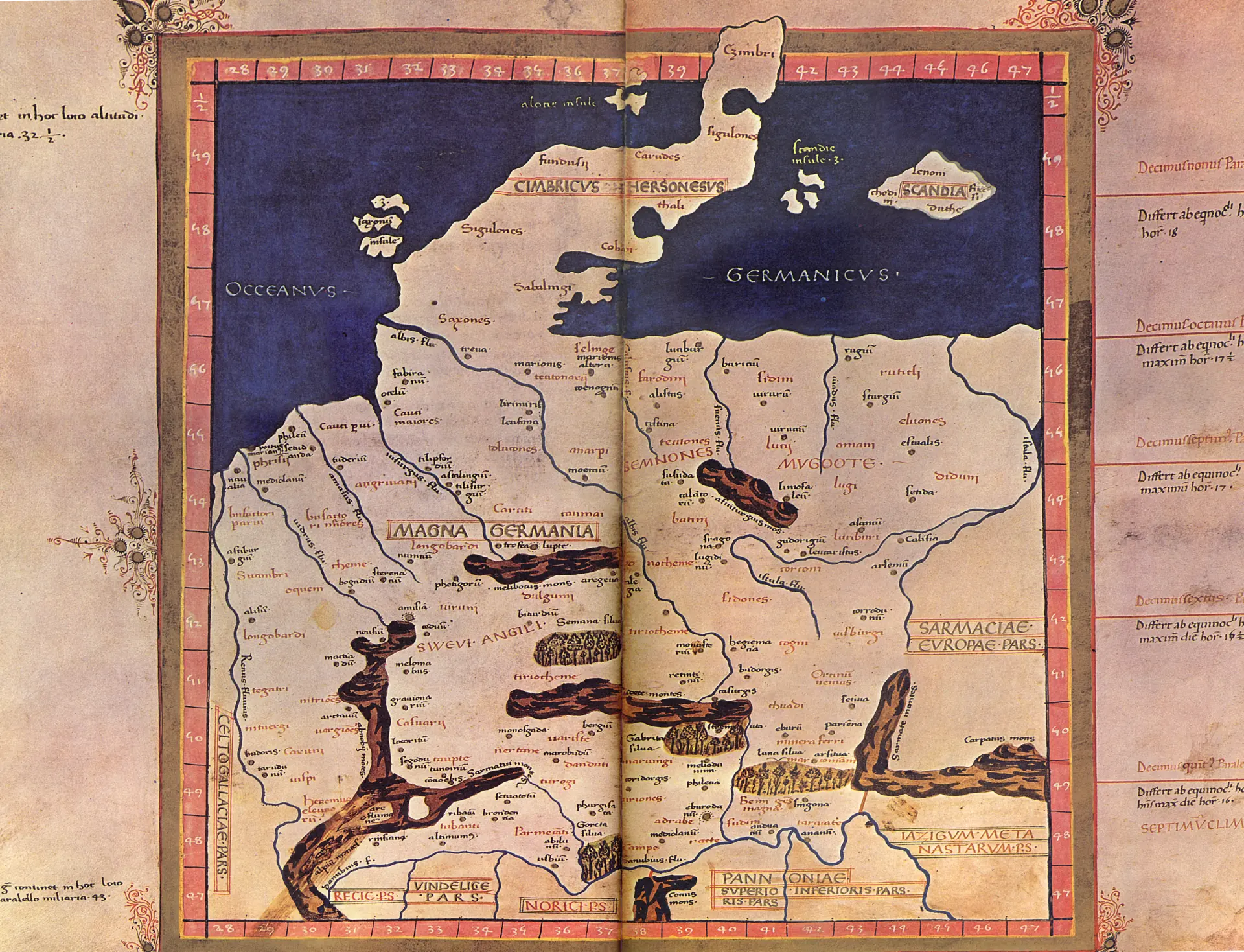
a. On Determining the Length of a Ptolemaic Degree One Ptolemaic degree in Germania Magna is approximately 28 kilometers (or 17.4 miles) wide.(see calculation→) b. Note on the term “Vistula Fluvius”: It is possible that the Greek term Οὐστούλα (Oustoúla) was originally adopted from Latin (i.e., by the Romans), with even older roots potentially found in the Celtic language or possibly that of the Jastorf Culture.In Latin, the word ustula is the imperative of ustulō and means “to burn something,” “to scorch something,” or also “to consume something with fire” – here to be understood as an order to someone or something to char or smolder something. There is probably also a closer connection to metalworking (especially charcoal burning), which is particularly indicated by the English cognate ustulate – as an adjective meaning “blackened” or “burnt” (Blackened as if burned) and as a verb directly referring to the “burning or … Read moreAdditional Notes on the Geography of Germania Magna

The Reinterpretation of Claudius Ptolemy’s Germania Magna by Sven Mildner


Sven Mildner - Neuinterpretation der Germania Magna des Claudius Ptolemy - EVROPA TABVLA QVARTA – Quarta Europe Tabula continet Germaniam cum insulis sibi adiacentibus. Die Karte zu ''Magna Germania'' aus der im Original griechisch verfaßten ''Geographike Hyphegesis'' des in Alexandria wirkenden Claudius Ptolemaios

DOI https://doi.org/10.31223/X5313TSven Mildner 0009-0005-8248-4866 In his draft for the Reinterpretation of Claudius Ptolemy’s Germania Magna – using computer-aided distortion analysis of a medieval map representation by Donnus Nicolaus Germanus – and considerations of post-glacial geodynamics of Europe, the author describes his assumption that Germania Magna underwent a far more extensive landscape transformation in geologically recent times than previously assumed. This transformation may have been caused by post-glacial land uplift in the Holocene or potentially by a reactivation of the Caledonian Deformation Front (CDF) during a late activity phase of the Alpine orogeny, accompanied by tectonic activities in the upper Earth’s crust. Additionally, the possibility that a cosmic impact event triggered such a reactivation of the CDF is not excluded. The conditions expected to justify the described process likely align with hitherto misattributed or incorrectly dated large-scale fracturing events, which might have led to significant earthquakes in Central Europe over several … Read moreThe Reinterpretation of Claudius Ptolemy’s Germania Magna by Sven Mildner

x  Powerful Protection for WordPress, from Shield Security
This Site Is Protected By
Shield Security