© Roman Eisele / Wikimedia Commons / CC BY-SA 4.0
.

On this page, you will find a collection of links to scientific publications that are relevant to this project or that can contribute to a deeper exemplary understanding of the processes and circumstances that may be related to the Reinterpretation of Germania Magna presented here. These publications span different research areas.

The collection includes:

  • Primary literature: Scientific publications presenting the results of new research.
  • Secondary literature: Scientific publications summarizing, analyzing, or interpreting primary literature.
  • Comparative literature: Publications that exemplify similar processes and circumstances in other contexts.
  • Additional resources: Links to websites, databases, and other resources that may be relevant to the reinterpretation

The following publications are intended to help answer specific questions exemplarily, which may be related to the necessary processes and events required for extensive landscape transformation. These include considerations of tectonic fracture events and rift systems, with corresponding effects on maritime landslide events and the formation of new sedimentation basins.


Foraminifera in the glacial erratic rock Sternberger Gestein from northern Germany


„Sternberger Kuchen“, ein vom Transport durch Eis und Wasser geformtes Stück Gestein der proximalen Tempestitfazies der Sülstorf-Schichten, File:StadtmuseumBerlin GeologischeSammlung SM-2012-4234.jpg. (2022, December 6). Wikimedia Commons. Retrieved 00:43, February 4, 2025 from https://commons.wikimedia.org/w/index.php?title=File:StadtmuseumBerlin_GeologischeSammlung_SM-2012-4234.jpg&oldid=712956671.

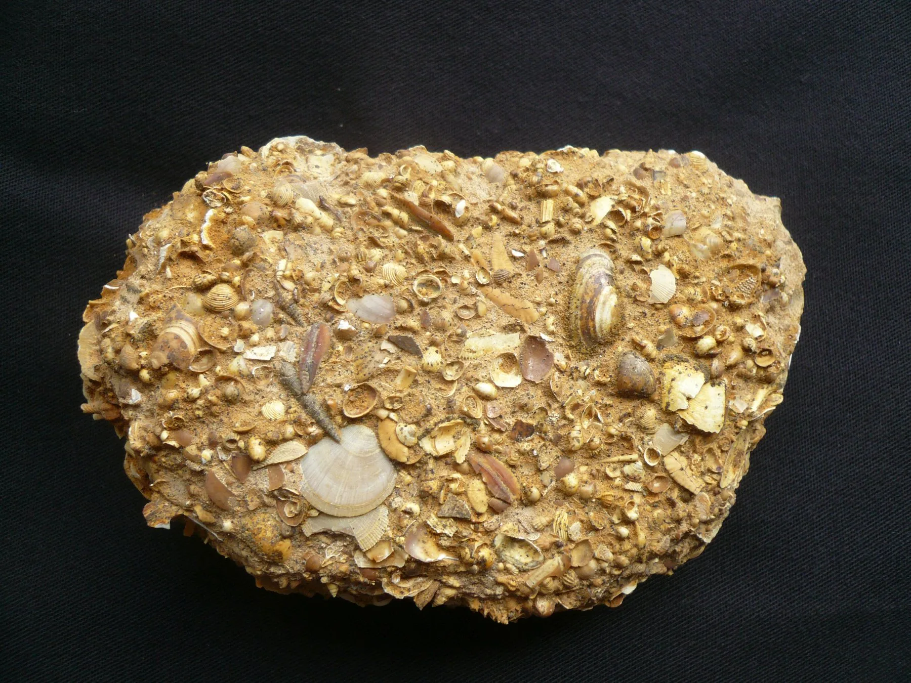
DOI http://dx.doi.org/10.61551/gsjfr.54.3.249 Abstract This study is part of a project that aims to provide the first comprehensive analysis of foraminifera in glacial erratics. Such studies may be used to clarify the origin of glacial erratics and serve as indicators of the direction of glacial movements. The glacial erratics, which were deposited during the Pleistocene Ice Ages, cover vast areas in northern Germany and beyond. The origin of erratics with fossil content can be clarified by correlating them with undisturbed strata. The foraminiferal assemblages of 21 pieces of the glacial erratic Sternberger Gestein (SG) are documented and illustrated. A total of 82 foraminiferal taxa were found, of which 69 taxa were illustrated, representing 97% of the counted specimens. Cluster analysis and analysis of similarities were used to determine the affinities between pieces. Based on previous borehole studies, the fauna in the SG pieces can be correlated regionally with the Palmula oblonga … Read moreForaminifera in the glacial erratic rock Sternberger Gestein from northern Germany

A new tectonic model for the Laurentia-Avalonia-Baltica sutures in the North Sea: A case study along MONA LISA profile 3


Lyngsie, S.B. & Thybo, H.. (2007). A new tectonic model for the Laurentia−Avalonia−Baltica sutures in the North Sea: A case study along MONA LISA profile 3. Tectonophysics. 429. 201-227. 10.1016/j.tecto.2006.09.017.

DOI http://dx.doi.org/10.1016/j.tecto.2006.09.017 Abstract We present a new model for the lithospheric structure of the transitions between Laurentia, Avalonia and Baltica in the North Sea, northwestern Europe based on 2¾D potential field modelling of MONA LISA profile 3 across the Central Graben, with constraints from seismic P-wave velocity models and the crustal normal incidence reflection section along the profile. The model shows evidence for the presence of upper-and lower Palaeozoic sedimentary rocks as well as differences in crustal structure between the palaeo-continents Laurentia, Avalonia and Baltica. Our new model, together with previous results from transformations of the gravity and magnetic fields, demonstrates correlation between crustal magnetic domains along the profile and the terrane affinity of the crust. This integrated interpretation indicates that a 150 km wide zone, characterized by low-grade metamorphosis and oblique thrusting of Avalonia crust over Baltica lower crust, is characteristic for the central North Sea area. The magnetic … Read moreA new tectonic model for the Laurentia-Avalonia-Baltica sutures in the North Sea: A case study along MONA LISA profile 3

Seismic velocity structure of crustal intrusions in the Danish Basin


Simpli fi ed map of the main tectonic features in the Danish Basin and surrounding areas. Abbreviations: CDF = Caledonian Deformation Front; STZ = Sorgenfrei-Tornquist Zone; TF = Tornquist Fan (light grey); MNRFH = Mid North Sea-Ringkøbing-Fyn High; TESZ = Trans-European Suture Zone; DB = Danish Basin; CG = Central Graben; HG = Horn Graben; BG = Brande Graben; OG = Oslo Graben; SG = Skagerrak Graben. Inset shows location of study area in Europe. After Berthelsen (1992), MONA LISA Working Group (1997b) and Ziegler (1990).

DOI 10.1016/j.tecto.2011.11.019 We image the east- and westward extent of a crustal high-velocity body, the thickness of a layered sequence around the Moho at the flank of the body, and the uppermost mantle velocity along the 320 km long refraction and wide-angle reflection seismic profile ESTRID 2007 in the Danish Basin. Ray-tracing modelling of the seismic data reveals a high-velocity body (6.7-7.7 km/s between 10 and 30 km depth) with a lateral extent of at least 110 km. It is interpreted as an intrusive body of gabbroic composition. Moho depth is variable between 30 and 35 km along the profile. The crust is thin in a similar to 180 km wide zone approximately below the western part of the intrusive body and further westward in the basin area. The Pn velocity in the uppermost mantle is relatively low (similar to 7.8 km/s) beneath the thin crust whereas higher Pn velocities … Read moreSeismic velocity structure of crustal intrusions in the Danish Basin

Dynamics of Mid-Palaeocene North Atlantic rifting linked with European intra-plate deformations


Nielsen, S., Stephenson, R. & Thomsen, E. Dynamics of Mid-Palaeocene North Atlantic rifting linked with European intra-plate deformations. Nature 450, 1071–1074 (2007).

DOI https://doi.org/10.1038/nature06379 Abstract The process of continental break-up provides a large-scale experiment that can be used to test causal relations between plate tectonics and the dynamics of the Earth’s deep mantle1,2. Detailed diagnostic information on the timing and dynamics of such events, which are not resolved by plate kinematic reconstructions, can be obtained from the response of the interior of adjacent continental plates to stress changes generated by plate boundary processes. Here we demonstrate a causal relationship between North Atlantic continental rifting at ∼62 Myr ago and an abrupt change of the intra-plate deformation style in the adjacent European continent. The rifting involved a left-lateral displacement between the North American-Greenland plate and Eurasia, which initiated the observed pause in the relative convergence of Europe and Africa3. The associated stress change in the European continent was significant and explains the sudden termination of a ∼20-Myr-long contractional intra-plate deformation within Europe4, during the late Cretaceous … Read moreDynamics of Mid-Palaeocene North Atlantic rifting linked with European intra-plate deformations

A submerged Stone Age hunting architecture from the Western Baltic Sea


Geersen, Jacob & Bradtmöller, Marcel & Schneider von Deimling, Jens & Feldens, Peter & Auer, Jens & Held, Philipp & Lohrberg, Arne & Supka, Ruth & Hoffmann, Jasper & Eriksen, Berit & Rabbel, Wolfgang & Karlsen, Hans-Jörg & Krastel, Sebastian & Brandt, David & Heuskin, David & Lübke, Harald. (2024). A submerged Stone Age hunting architecture from the Western Baltic Sea. Proceedings of the National Academy of Sciences of the United States of America. 121. e2312008121. 10.1073/pnas.2312008121.

DOI https://doi.org/10.1073/pnas.2312008121 Abstract The Baltic Sea basins, some of which only submerged in the mid-Holocene, preserve Stone Age structures that did not survive on land. Yet, the discovery of these features is challenging and requires cross-disciplinary approaches between archeology and marine geosciences. Here, we combine shipborne and autonomousunderwater vehicle hydroacoustic data with up to a centimeter range resolution, sedimentological samples, and optical images to explore a Stone Age megastructure located in 21 m water depth in the Bay of Mecklenburg, Germany. The structure is made of 1,673 individual stones which are usually less than 1 m in height, placed side by side over a distance of 971 m in a way that argues against a natural origin by glacial transport or ice push ridges. Running adjacent to the sunken shoreline of a paleolake (or bog), whose youngest phase was dated to 9,143 ±36 ka B.P., the stonewall was likely used … Read moreA submerged Stone Age hunting architecture from the Western Baltic Sea

Sea-level change, glacial rebound and mantle viscosity for northern Europe


Kurt Lambeck, Catherine Smither, Paul Johnston, Sea-level change, glacial rebound and mantle viscosity for northern Europe, Geophysical Journal International, Volume 134, Issue 1, July 1998, Pages 102–144

DOI https://doi.org/10.1046/j.1365-246x.1998.00541.x Abstract Northwestern Europe remains a key region for testing models of glacial isostasy because of the good geological record of crustal response to the glacial unloading since the time of the Last Glacial Maximum. Models for this rebound and associated sea-level change require a detailed knowledge of the ice-sheet geometry, including the ice thickness through time. Existing ice-sheet reconstructions are strongly model-dependent, and inversions of sea-level data for the mantle response may be a function of the model assumptions. Thus inverse solutions for the sea-level data are sought that include both ice- and earth-model parameters as unknowns. Sea-level data from Fennoscandia, the North Sea, the British Isles and the Atlantic and English Channel coasts have been evaluated and incorporated into the solutions. The starting ice sheet for Fennoscandia is based on a reconstruction of a model by Denton & Hughes (1981) that is characterized by quasi-parabolic cross-sections and … Read moreSea-level change, glacial rebound and mantle viscosity for northern Europe

Continuous record of Holocene sea-level changes and coastal development of the Kattegat island Læsø (4900 years BP to present)


Hansen, Jens & Aagaard, Troels & Stockmarr, Jens & Møller, Ingelise & Nielsen, Lars & Binderup, Merete & Larsen, Jan & Larsen, Birger. (2016). Continuous record of Holocene sea-level changes and coastal development of the Kattegat island Læsø (4900 years BP to present). Bulletin of the Geological Society of Denmark. 64. 10.37570/bgsd-2016-64-01.

DOI http://dx.doi.org/10.37570/bgsd-2016-64-01 Læsø is the largest island of the Kattegat–Skagerrak region and exposes a vast array of relative sealevel (RSL) indicators, mainly raised beach ridges, swales, lagoons and saltmarshes. The physical environment of continuous glacial rebound, excessive supply of sediment, shallow surrounding waters, low amplitudes of near-shore waves, and micro-tidal conditions produced numerous sealevel proxies of both barrier coasts and saltmarshes. About 1200 RSL/age index points reflect not only short-term sea-level highstands as in most other parts of Europe, but also short-term sea-level lowstands, which in less regressive environments have normally been removed by coastal erosion or obscured by berms from subsequent highstands. Based on a high-precision lidar digital terrain model, the beach ridges have been mapped, typified, levelled and correlated relative to their order of appearance. Transformation of this relative chronology to a robust absolute age model of the RSL changes has been made on the basis of 119 … Read moreContinuous record of Holocene sea-level changes and coastal development of the Kattegat island Læsø (4900 years BP to present)

Holocene Relative Sea-Level Changes from Near-, Intermediate-, and Far-Field Locations


Khan, Nicole & Ashe, Erica & Shaw, Timothy & Vacchi, Matteo & Walker, Jennifer & Peltier, W. & Kopp, Robert & Horton, Benjamin. (2015). Holocene Relative Sea-Level Changes from Near-, Intermediate-, and Far-Field Locations. Current Climate Change Reports. 1. 10.1007/s40641-015-0029-z.

DOI https://dx.doi.org/10.1007/s40641-015-0029-z Abstract Holocene relative sea-level (RSL) records exhibit spatial and temporal variability that arises mainly from the interaction of eustatic (land ice volume and thermal expansion) and isostatic (glacio- and hydro-) factors. We fit RSL histories from near-, intermediate-, and far-field locations with noisy-input Gaussian process models to assess rates of RSL change. Records from near-field regions (e.g., Antarctica, Greenland, Canada, Sweden, and Scotland) reveal a complex pattern of RSL fall from a maximum marine limit due to the net effect of eustatic sea-level rise and glacio-isostatic uplift with rates of RSL fall as great as −69 ± 9 m/ka. Intermediate-field regions (e.g., mid-Atlantic and Pacific coasts of the USA, Netherlands, Southern France, St. Croix) display variable rates of RSL rise from the cumulative effect of eustatic and isostatic factors. Fast rates of RSL rise (up to 10 ± 1 m/ka) are found in the early Holocene in regions … Read moreHolocene Relative Sea-Level Changes from Near-, Intermediate-, and Far-Field Locations

The catastrophic final flooding of Doggerland by the Storegga Slide tsunami


Weninger, Bernhard & Schulting, Rick & Bradtmöller, Marcel & Clare, Lee & Collard, Mark & Edinborough, Kevan & Hilpert, Johanna & Jöris, Olaf & Niekus, Marcel & Rohling, Eelco & Wagner, Bernd. (2008). The catastrophic final flooding of Doggerland by the Storegga Slide tsunami. Documenta Praehistorica XXXV. 34426126. 10.4312/dp.35.1.

DOI https://doi.org/10.4312/dp.35.1 Abstract Around 8200 calBP, large parts of the now submerged North Sea continental shelf (‘Doggerland’) were catastrophically flooded by the Storegga Slide tsunami, one of the largest tsunamis known for the Holocene, which was generated on the Norwegian coastal margin by a submarine landslide. In the present paper, we derive a precise calendric date for the Storegga Slide tsunami, use this date for reconstruction of contemporary coastlines in the North Sea in relation to rapidly rising sea-levels, and discuss the potential effects of the tsunami on the contemporaneous Mesolithic population. One main result of this study is an unexpectedly high tsunami impact assigned to the western regions of Jutland. Weninger, B., Schulting, R., Bradtmöller, M., Clare, L., Collard, M., Edinborough, K., Hilpert, J., Jöris, O., Niekus, M., Rohling, E. J., & Wagner, B. (2008). The catastrophic final flooding of Doggerland by the Storegga Slide tsunami. Documenta Praehistorica, 35, 1-24. https://doi.org/10.4312/dp.35.1

Rapid Quaternary subsidence in the northwestern German North Sea


Arfai, Jashar & Franke, Dieter & Lutz, Rüdiger & Reinhardt, Lutz & Kley, Jonas & Gaedicke, Christoph. (2018). Rapid Quaternary subsidence in the northwestern German North Sea. Scientific Reports. 8. 10.1038/s41598-018-29638-6.

DOI https://doi.org/10.1038/s41598-018-29638-6 Abstract 3D and 2D seismic data reveal the base-reflection of the Quaternary in the northwestern German North Sea locally at depths of more than 1000 m. This indicates extremely fast subsidence, with a rate of up to 480 m/Ma during the Quaternary, resulting in a NNW-SSE oriented sedimentary depocentre. Distinct iceberg scour marks, identified in 3D seismic data are used to calibrate quantitative subsidence analysis and to document shallow marine conditions during the Quaternary interglacials. Previously, a number of mechanisms have been proposed to explain the Quaternary subsidence. Here we show that compaction and load-induced subsidence alone explain about 75% of the observed Quaternary subsidence. However, a certain portion of the subsidence needs additional processes to be invoked. The extensive seismic dataset interpreted here makes it possible to exclude a phase of renewed tectonic activity as the origin of the subsidence anomaly. From the orientation and extent of the depocentre, … Read moreRapid Quaternary subsidence in the northwestern German North Sea

x  Powerful Protection for WordPress, from Shield Security
This Site Is Protected By
Shield Security