© Roman Eisele / Wikimedia Commons / CC BY-SA 4.0
.

On this page, you will find a collection of links to scientific publications that are relevant to this project or that can contribute to a deeper exemplary understanding of the processes and circumstances that may be related to the Reinterpretation of Germania Magna presented here. These publications span different research areas.

The collection includes:

  • Primary literature: Scientific publications presenting the results of new research.
  • Secondary literature: Scientific publications summarizing, analyzing, or interpreting primary literature.
  • Comparative literature: Publications that exemplify similar processes and circumstances in other contexts.
  • Additional resources: Links to websites, databases, and other resources that may be relevant to the reinterpretation

The following publications are intended to help answer specific questions exemplarily, which may be related to the necessary processes and events required for extensive landscape transformation. These include considerations of tectonic fracture events and rift systems, with corresponding effects on maritime landslide events and the formation of new sedimentation basins.


Cataclysm!: Compelling Evidence of a Cosmic Catastrophe in 9500 B.C.


Allan, D.S.; Delair, J.B. (1997): Cataclysm!: Compelling Evidence of a Cosmic Catastrophe in 9500 B.C. Rochester: Inner Traditions/Bear

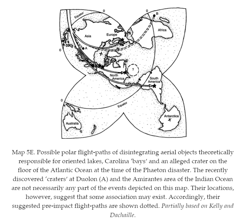
Description Follow this multi-disciplinary, scientific study as it examines the evidence of a great global catastrophe that occurred only 11,500 years ago. Crustal shifting, the tilting of Earth’s axis, mass extinctions, upthrusted mountain ranges, rising and shrinking land masses, and gigantic volcanic eruptions and earthquakes–all indicate that a fateful confrontation with a destructive cosmic visitor must have occurred. The abundant geological, biological, and climatological evidence from this dire event calls into question many geological theories and will awaken our memories to our true–and not-so-distant–past. Allan, D.S.; Delair, J.B. (1997): Cataclysm!: Compelling Evidence of a Cosmic Catastrophe in 9500 B.C. Rochester: Inner Traditions/Bear

DIE ENTSTEHUNG DES VULKANISCHEN KAOLINS UND DAS ANDESIT-PROBLEM


SEYHAN, İsmail (2023) "DIE ENTSTEHUNG DES VULKANISCHEN KAOLINS UND DAS ANDESIT-PROBLEM*," Bulletin of the Mineral Research and Exploration: Vol. 1971: Iss. 76, Article 6.

Die Kaoline werden in Literatur meist als Verwitterungsprodukte feldspatreicher, saurer Gesteine betrachtet. Die im Zuge der schnellen Aufwärtsentwicklung der keramischen Industrie vorangetriebenen Arbeiten über die Kaolin-Geologie zeigten es, dass die türkischen Kaoline hauptsächlich an die vulkanischen Gesteine gebunden sind. Für die Bildung der Kaolinlagerstätten ist es notwendig, dass die Kaolinisierung der Feldspäte schon während der vulkanischen und magmatischen Vorgänge einsetzt. Der schnelle und umfangreiche Wechsel des pH Wertes ist für die Trennung der Si- AI- und Fe-Oxyde wichtig. Diese chemischen Vorgänge und die Paragenese des Kaolinits mit den Mineralien vulkanischer und magmatischer Herkunft können nicht mit der Verwitterung durch die deszendenten Wässer allein erklärt werden. Sowohl die gangartigen, hydrothermalen Kaolinlagerstätten in magmatischen, subvulkanischen und vulkanischen Gesteinen, als auch die lateralen Kaolinisierungszonen sind hauptsächlich durch die Wirkung der sauren, thermalen Lösungen entstanden. SEYHAN, İsmail (2023) “DIE ENTSTEHUNG DES VULKANISCHEN KAOLINS UND DAS ANDESIT-PROBLEM*,” Bulletin of the Mineral Research and Exploration: Vol. 1971: … Read moreDIE ENTSTEHUNG DES VULKANISCHEN KAOLINS UND DAS ANDESIT-PROBLEM

Foraminifera in the glacial erratic rock Sternberger Gestein from northern Germany


„Sternberger Kuchen“, ein vom Transport durch Eis und Wasser geformtes Stück Gestein der proximalen Tempestitfazies der Sülstorf-Schichten, File:StadtmuseumBerlin GeologischeSammlung SM-2012-4234.jpg. (2022, December 6). Wikimedia Commons. Retrieved 00:43, February 4, 2025 from https://commons.wikimedia.org/w/index.php?title=File:StadtmuseumBerlin_GeologischeSammlung_SM-2012-4234.jpg&oldid=712956671.

DOI http://dx.doi.org/10.61551/gsjfr.54.3.249 Abstract This study is part of a project that aims to provide the first comprehensive analysis of foraminifera in glacial erratics. Such studies may be used to clarify the origin of glacial erratics and serve as indicators of the direction of glacial movements. The glacial erratics, which were deposited during the Pleistocene Ice Ages, cover vast areas in northern Germany and beyond. The origin of erratics with fossil content can be clarified by correlating them with undisturbed strata. The foraminiferal assemblages of 21 pieces of the glacial erratic Sternberger Gestein (SG) are documented and illustrated. A total of 82 foraminiferal taxa were found, of which 69 taxa were illustrated, representing 97% of the counted specimens. Cluster analysis and analysis of similarities were used to determine the affinities between pieces. Based on previous borehole studies, the fauna in the SG pieces can be correlated regionally with the Palmula oblonga … Read moreForaminifera in the glacial erratic rock Sternberger Gestein from northern Germany

The Chiemgau Meteorite Impact Strewn Field and the Digital Terrain Model: “Earthquake” Liquefaction from Above and from Below


Fig. 1. Location map for the Chiemgau impact region. Published in 2019 Cosmic collision in prehistory The Chiemgau Impact : research in a Bavarian meteorite crater strewn field, M. RappenglückB. Rappenglück, K. Ernstson

DOI http://dx.doi.org/10.13140/RG.2.2.11274.79041 Abstract The Chiemgau strewn field discovered and established in the early new millennium(Schryvers and Raeymaekers, 2004; Schüssler et al., 2005; Rösler et al. 2005, Rappenglück,M. et al., 2005, Hoffmann et al., 2005, 2006; Yang et al 2008), extensively investigated in thefollowing decade until today (Ernstson et al. 2010, 2011, 2012, 2013, 2014, 2017, 2020, 2023,2024, Hiltl et al. 2011, Isaenko et al. 2012, Rappenglück, B. et al. 2010, 2020 a, b, c, 2021,Rappenglück M.A, et al. 2013, 2014, Bauer et al. 2013, 2019, 2020, Shumilova et al. 2018,Ernstson and Poßekel 2017, 2020 a, b, 2024, Ernstson and Shumilova 2020, Poßekel andErnstson 2019, 2020), and dated to 900-600 BC in the Bronze Age/Iron Age (Rappenglück, B.et al. 2023) comprises far more than 100 mostly rimmed craters scattered in a region of about60 km length and ca. 30 km width in the very South-East of Germany. The crater diametersrange between … Read moreThe Chiemgau Meteorite Impact Strewn Field and the Digital Terrain Model: “Earthquake” Liquefaction from Above and from Below

Vulkanismus in Mitteldeutschland. Band 4: Explosiver Vulkanismus im Bereich der Halle-Störung. Die Campusbohrung 3 in Heide Süd


Grieswald, D. H. (2020): Vulkanismus in Mitteldeutschland. Band 2: Explosiver Vulkanismus im Bereich der Halle-Störung zwischen Halle (Saale) und Leipzig. Die Tiefbohrung Lochau 7/65.

Description This book series is a collection of application-oriented works from the years 2002–2020, focusing on volcanism in Saxony-Anhalt and Saxony. The works encompass engineering geological, geotechnical, and scientific aspects, highlighting various exposures and drillings at different locations. These are self-contained projects that, due to the overarching theme of volcanism, are nonetheless interconnected. Volume 1 begins with Permo-Carboniferous phreatomagmatic volcanism and molasse deposits in Halle (Saale) and concludes with Upper Cretaceous carbonatite volcanism near Roitzsch. Particular attention is drawn to Volume 10, which contains extensive volcanotectonic information on Central Germany as well as related regions in Europe and Africa, incorporating supplementary information from Volumes 1–9. Furthermore, the formation of the Halle Caldera and the ultramafic lamprophyre-carbonatite complex near Delitzsch-Brehna is discussed. The following collage was created in 2020 as part of the project aimed at understanding the volcanic rocks of Central Germany: Volcanism in Central Germany Volume 1: Depositional facies … Read moreVulkanismus in Mitteldeutschland. Band 4: Explosiver Vulkanismus im Bereich der Halle-Störung. Die Campusbohrung 3 in Heide Süd

Vulkanismus in Mitteldeutschland. Band 2: Explosiver Vulkanismus im Bereich der Halle-Störung zwischen Halle (Saale) und Leipzig. Die Tiefbohrung Lochau 7/65.


Grieswald, D. H. (2020): Vulkanismus in Mitteldeutschland. Band 2: Explosiver Vulkanismus im Bereich der Halle-Störung zwischen Halle (Saale) und Leipzig. Die Tiefbohrung Lochau 7/65.

Description This book series is a collection of application-oriented works from the years 2002–2020, focusing on volcanism in Saxony-Anhalt and Saxony. The works encompass engineering geological, geotechnical, and scientific aspects, highlighting various exposures and drillings at different locations. These are self-contained projects that, due to the overarching theme of volcanism, are nonetheless interconnected. Volume 1 begins with Permo-Carboniferous phreatomagmatic volcanism and molasse deposits in Halle (Saale) and concludes with Upper Cretaceous carbonatite volcanism near Roitzsch. Particular attention is drawn to Volume 10, which contains extensive volcanotectonic information on Central Germany as well as related regions in Europe and Africa, incorporating supplementary information from Volumes 1–9. Furthermore, the formation of the Halle Caldera and the ultramafic lamprophyre-carbonatite complex near Delitzsch-Brehna is discussed. The following collage was created in 2020 as part of the project aimed at understanding the volcanic rocks of Central Germany: Volcanism in Central Germany Volume 1: Depositional facies … Read moreVulkanismus in Mitteldeutschland. Band 2: Explosiver Vulkanismus im Bereich der Halle-Störung zwischen Halle (Saale) und Leipzig. Die Tiefbohrung Lochau 7/65.

A new tectonic model for the Laurentia-Avalonia-Baltica sutures in the North Sea: A case study along MONA LISA profile 3


Lyngsie, S.B. & Thybo, H.. (2007). A new tectonic model for the Laurentia−Avalonia−Baltica sutures in the North Sea: A case study along MONA LISA profile 3. Tectonophysics. 429. 201-227. 10.1016/j.tecto.2006.09.017.

DOI http://dx.doi.org/10.1016/j.tecto.2006.09.017 Abstract We present a new model for the lithospheric structure of the transitions between Laurentia, Avalonia and Baltica in the North Sea, northwestern Europe based on 2¾D potential field modelling of MONA LISA profile 3 across the Central Graben, with constraints from seismic P-wave velocity models and the crustal normal incidence reflection section along the profile. The model shows evidence for the presence of upper-and lower Palaeozoic sedimentary rocks as well as differences in crustal structure between the palaeo-continents Laurentia, Avalonia and Baltica. Our new model, together with previous results from transformations of the gravity and magnetic fields, demonstrates correlation between crustal magnetic domains along the profile and the terrane affinity of the crust. This integrated interpretation indicates that a 150 km wide zone, characterized by low-grade metamorphosis and oblique thrusting of Avalonia crust over Baltica lower crust, is characteristic for the central North Sea area. The magnetic … Read moreA new tectonic model for the Laurentia-Avalonia-Baltica sutures in the North Sea: A case study along MONA LISA profile 3

What caused terrestrial dust loading and climate downturns between A.D. 533 and 540?


What Caused Terrestrial Dust Loading and Climate Downturns Between 533 and 540 A.D.? Scanning electron microscope (SEM) micrographs of particles from the ice core. (A, C, E, J) Sn-rich particles with one Fe-rich spherule in E. (B, D, F, G, H) Qualitative energy-dispersive X-ray microanalyses of compositions. (Note that the peak heights are not absolute so no scale is given for peak heights. This means that the relative heights of nearby spectral peaks provide a good estimate of relative abundances of these elements. In contrast, the relative heights of peaks with different energies are only loosely correlated to their relative abundance.) Four out of fi ve analyses are of Sn-rich particles. Analysis D shows a small but distinct Cu peak in addition to Sn peaks. The remaining analysis is of a Fe-rich spherule (F). (I) Ni-rich particle-analysis in Table 3. Ratios of backscattered and secondary electrons were adjusted to maximum the image quality: (A) 100% BSE (backscattered electron mode); (C, I) 50% BSE, 50% ILSE (in-lens secondary electron mode); (E) 90% BSE, 10% ILSE, (J) 50% BSE, 50% SE2 (standard secondary electron mode). Black arrows or lines point from particles to their spectra.

DOI https://doi.org/10.1130/2014.2505(23) Abstract Sn-rich particles, Ni-rich particles, and cosmic spherules are found together at four discrete stratigraphic levels within the 362–360 m depth interval of the Greenland Ice Sheet Project 2 (GISP2) ice core (72.6°N, 38.5°W, elevation: 3203 m). Using a previously derived calendar-year time scale, these particles span a time of increased dust loading of Earth’s atmosphere between A.D. 533 and 540. The Sn-rich and Ni-rich particles contain an average of 10–11 wt% C. Their high C contents coupled with local enrichments in the volatile elements I, Zn, Cu, and Xe suggest a cometary source for the dust. The late spring timing of extraterrestrial input best matches the Eta Aquarid meteor shower associated with comet 1P/Halley. An increased flux of cometary dust might explain a modest climate downturn in A.D. 533. Both cometary dust and volcanic sulfate probably contributed to the profound global dimming during A.D. 536 and 537 … Read moreWhat caused terrestrial dust loading and climate downturns between A.D. 533 and 540?

Continental-scale temperature variability during the past two millennia


Summary of long-term trends in individual site-level proxy records.

DOI https://doi.org/10.1038/ngeo1797 Abstract Past global climate changes had strong regional expression. To elucidate their spatio-temporal pattern, we reconstructed past temperatures for seven continental-scale regions during the past one to two millennia. The most coherent feature in nearly all of the regional temperature reconstructions is a long-term cooling trend, which ended late in the nineteenth century. At multi-decadal to centennial scales, temperature variability shows distinctly different regional patterns, with more similarity within each hemisphere than between them. There were no globally synchronous multi-decadal warm or cold intervals that define a worldwide Medieval Warm Period or Little Ice Age, but all reconstructions show generally cold conditions between AD 1580 and 1880, punctuated in some regions by warm decades during the eighteenth century. The transition to these colder conditions occurred earlier in the Arctic, Europe and Asia than in North America or the Southern Hemisphere regions. Recent warming reversed the long-term cooling; during the period AD 1971–2000, … Read moreContinental-scale temperature variability during the past two millennia

Seismic velocity structure of crustal intrusions in the Danish Basin


Simpli fi ed map of the main tectonic features in the Danish Basin and surrounding areas. Abbreviations: CDF = Caledonian Deformation Front; STZ = Sorgenfrei-Tornquist Zone; TF = Tornquist Fan (light grey); MNRFH = Mid North Sea-Ringkøbing-Fyn High; TESZ = Trans-European Suture Zone; DB = Danish Basin; CG = Central Graben; HG = Horn Graben; BG = Brande Graben; OG = Oslo Graben; SG = Skagerrak Graben. Inset shows location of study area in Europe. After Berthelsen (1992), MONA LISA Working Group (1997b) and Ziegler (1990).

DOI 10.1016/j.tecto.2011.11.019 We image the east- and westward extent of a crustal high-velocity body, the thickness of a layered sequence around the Moho at the flank of the body, and the uppermost mantle velocity along the 320 km long refraction and wide-angle reflection seismic profile ESTRID 2007 in the Danish Basin. Ray-tracing modelling of the seismic data reveals a high-velocity body (6.7-7.7 km/s between 10 and 30 km depth) with a lateral extent of at least 110 km. It is interpreted as an intrusive body of gabbroic composition. Moho depth is variable between 30 and 35 km along the profile. The crust is thin in a similar to 180 km wide zone approximately below the western part of the intrusive body and further westward in the basin area. The Pn velocity in the uppermost mantle is relatively low (similar to 7.8 km/s) beneath the thin crust whereas higher Pn velocities … Read moreSeismic velocity structure of crustal intrusions in the Danish Basin

x  Powerful Protection for WordPress, from Shield Security
This Site Is Protected By
Shield Security