© Roman Eisele / Wikimedia Commons / CC BY-SA 4.0
.

Auf dieser Seite finden Sie eine Sammlung von Links zu wissenschaftlichen Veröffentlichungen, die für dieses Projekt relevant sind oder die dazu beitragen können, ein tieferes exemplarisches Verständnis über die Prozesse und Umstände zu erlangen, welche möglicherweise in einem Zusammenhang mit der hier vorgestellten Neuinterpretation der Germania Magna stehen. Dabei handelt es sich um Veröffentlichungen unterschiedlicher Forschungsbereiche.

Die Sammlung umfasst:

  • Primärliteratur: Wissenschaftliche Veröffentlichungen, die die Ergebnisse neuer Forschung präsentieren.
  • Sekundärliteratur: Wissenschaftliche Veröffentlichungen, die die Primärliteratur zusammenfassen, analysieren oder interpretieren.
  • Vergleichende Literatur: Veröffentlichungen, die Ihnen exemplarisch ähnliche Prozesse und Umstände in anderen Kontexten aufzeigen.
  • Weitere Ressourcen: Links zu Websites, Datenbanken und anderen Ressourcen, die für die Neuinterpretation relevant sein können.

Die folgenden Publikationen sollen dabei helfen, bestimmte Fragestellungen exemplarisch zu beantworten, welche in einem möglichen Zusammenhang mit den notwendigen Prozessen und Vorgängen stehen, die für eine umfangreiche Landschaftstransformation erforderlich sind. Hierzu zählen beispielsweise Überlegungen über tektonische Bruchereignisse und Rift-Systeme, mit entsprechender Auswirkung auf maritime Rutschungsereignisse und die Entstehung neuer Sedimentationsbecken.


How to reconstruct trends of late Holocene relative sea level: A new approach using tidal flat clastic sediments and optical dating


Mauz, B., & Bungenstock, F. (2007). How to reconstruct trends of late Holocene relative sea level: A new approach using tidal flat clastic sediments and optical dating. Marine Geology, 237(3-4), 225-237.

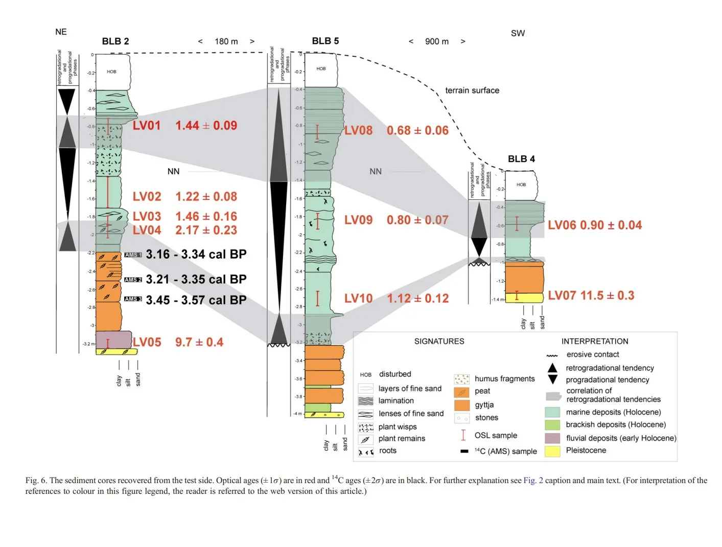
DOI https://doi.org/10.1016/j.margeo.2006.12.001 Abstract Assessment of ongoing relative sea level rise in NW-Europe for individual tidal basins is wanted and, consequently, a variety of methods must be available for investigations under different local conditions. The methodology presented in this paper is based on OSL (optically stimulated luminescence) dating of tidal flat sedimentary records. It uses a conceptual model that assumes that tidal flat clastic sediments record small changes in sea level trend. These changes are in NW-Europe superimposed on the general rising trend of the near-field sea level during the late Holocene (last ∼3500 years). The dating approach can be complemented by 210Pb-dating for the most recent period (last ∼100 years). This combination has the potential to bridge between contrasting short-term and long-term data about sea level change.The paper describes the model for sedimentation and the dating technique. The accuracy of the method is assessed at a test site on the … WeiterlesenHow to reconstruct trends of late Holocene relative sea level: A new approach using tidal flat clastic sediments and optical dating

Foraminifera in the glacial erratic rock Sternberger Gestein from northern Germany


„Sternberger Kuchen“, ein vom Transport durch Eis und Wasser geformtes Stück Gestein der proximalen Tempestitfazies der Sülstorf-Schichten, File:StadtmuseumBerlin GeologischeSammlung SM-2012-4234.jpg. (2022, December 6). Wikimedia Commons. Retrieved 00:43, February 4, 2025 from https://commons.wikimedia.org/w/index.php?title=File:StadtmuseumBerlin_GeologischeSammlung_SM-2012-4234.jpg&oldid=712956671.

DOI http://dx.doi.org/10.61551/gsjfr.54.3.249 Abstract This study is part of a project that aims to provide the first comprehensive analysis of foraminifera in glacial erratics. Such studies may be used to clarify the origin of glacial erratics and serve as indicators of the direction of glacial movements. The glacial erratics, which were deposited during the Pleistocene Ice Ages, cover vast areas in northern Germany and beyond. The origin of erratics with fossil content can be clarified by correlating them with undisturbed strata. The foraminiferal assemblages of 21 pieces of the glacial erratic Sternberger Gestein (SG) are documented and illustrated. A total of 82 foraminiferal taxa were found, of which 69 taxa were illustrated, representing 97% of the counted specimens. Cluster analysis and analysis of similarities were used to determine the affinities between pieces. Based on previous borehole studies, the fauna in the SG pieces can be correlated regionally with the Palmula oblonga … WeiterlesenForaminifera in the glacial erratic rock Sternberger Gestein from northern Germany

A new tectonic model for the Laurentia-Avalonia-Baltica sutures in the North Sea: A case study along MONA LISA profile 3


Lyngsie, S.B. & Thybo, H.. (2007). A new tectonic model for the Laurentia−Avalonia−Baltica sutures in the North Sea: A case study along MONA LISA profile 3. Tectonophysics. 429. 201-227. 10.1016/j.tecto.2006.09.017.

DOI http://dx.doi.org/10.1016/j.tecto.2006.09.017 Abstract We present a new model for the lithospheric structure of the transitions between Laurentia, Avalonia and Baltica in the North Sea, northwestern Europe based on 2¾D potential field modelling of MONA LISA profile 3 across the Central Graben, with constraints from seismic P-wave velocity models and the crustal normal incidence reflection section along the profile. The model shows evidence for the presence of upper-and lower Palaeozoic sedimentary rocks as well as differences in crustal structure between the palaeo-continents Laurentia, Avalonia and Baltica. Our new model, together with previous results from transformations of the gravity and magnetic fields, demonstrates correlation between crustal magnetic domains along the profile and the terrane affinity of the crust. This integrated interpretation indicates that a 150 km wide zone, characterized by low-grade metamorphosis and oblique thrusting of Avalonia crust over Baltica lower crust, is characteristic for the central North Sea area. The magnetic … WeiterlesenA new tectonic model for the Laurentia-Avalonia-Baltica sutures in the North Sea: A case study along MONA LISA profile 3

Seismic velocity structure of crustal intrusions in the Danish Basin


Simpli fi ed map of the main tectonic features in the Danish Basin and surrounding areas. Abbreviations: CDF = Caledonian Deformation Front; STZ = Sorgenfrei-Tornquist Zone; TF = Tornquist Fan (light grey); MNRFH = Mid North Sea-Ringkøbing-Fyn High; TESZ = Trans-European Suture Zone; DB = Danish Basin; CG = Central Graben; HG = Horn Graben; BG = Brande Graben; OG = Oslo Graben; SG = Skagerrak Graben. Inset shows location of study area in Europe. After Berthelsen (1992), MONA LISA Working Group (1997b) and Ziegler (1990).

DOI https://doi.org/10.1016/j.tecto.2011.11.019 We image the east- and westward extent of a crustal high-velocity body, the thickness of a layered sequence around the Moho at the flank of the body, and the uppermost mantle velocity along the 320 km long refraction and wide-angle reflection seismic profile ESTRID 2007 in the Danish Basin. Ray-tracing modelling of the seismic data reveals a high-velocity body (6.7-7.7 km/s between 10 and 30 km depth) with a lateral extent of at least 110 km. It is interpreted as an intrusive body of gabbroic composition. Moho depth is variable between 30 and 35 km along the profile. The crust is thin in a similar to 180 km wide zone approximately below the western part of the intrusive body and further westward in the basin area. The Pn velocity in the uppermost mantle is relatively low (similar to 7.8 km/s) beneath the thin crust whereas higher Pn velocities … WeiterlesenSeismic velocity structure of crustal intrusions in the Danish Basin

Dynamics of Mid-Palaeocene North Atlantic rifting linked with European intra-plate deformations


Nielsen, S., Stephenson, R. & Thomsen, E. Dynamics of Mid-Palaeocene North Atlantic rifting linked with European intra-plate deformations. Nature 450, 1071–1074 (2007).

DOI https://doi.org/10.1038/nature06379 Abstract The process of continental break-up provides a large-scale experiment that can be used to test causal relations between plate tectonics and the dynamics of the Earth’s deep mantle1,2. Detailed diagnostic information on the timing and dynamics of such events, which are not resolved by plate kinematic reconstructions, can be obtained from the response of the interior of adjacent continental plates to stress changes generated by plate boundary processes. Here we demonstrate a causal relationship between North Atlantic continental rifting at ∼62 Myr ago and an abrupt change of the intra-plate deformation style in the adjacent European continent. The rifting involved a left-lateral displacement between the North American-Greenland plate and Eurasia, which initiated the observed pause in the relative convergence of Europe and Africa3. The associated stress change in the European continent was significant and explains the sudden termination of a ∼20-Myr-long contractional intra-plate deformation within Europe4, during the late Cretaceous … WeiterlesenDynamics of Mid-Palaeocene North Atlantic rifting linked with European intra-plate deformations

A submerged Stone Age hunting architecture from the Western Baltic Sea


Geersen, Jacob & Bradtmöller, Marcel & Schneider von Deimling, Jens & Feldens, Peter & Auer, Jens & Held, Philipp & Lohrberg, Arne & Supka, Ruth & Hoffmann, Jasper & Eriksen, Berit & Rabbel, Wolfgang & Karlsen, Hans-Jörg & Krastel, Sebastian & Brandt, David & Heuskin, David & Lübke, Harald. (2024). A submerged Stone Age hunting architecture from the Western Baltic Sea. Proceedings of the National Academy of Sciences of the United States of America. 121. e2312008121. 10.1073/pnas.2312008121.

DOI https://doi.org/10.1073/pnas.2312008121 Abstract The Baltic Sea basins, some of which only submerged in the mid-Holocene, preserve Stone Age structures that did not survive on land. Yet, the discovery of these features is challenging and requires cross-disciplinary approaches between archeology and marine geosciences. Here, we combine shipborne and autonomousunderwater vehicle hydroacoustic data with up to a centimeter range resolution, sedimentological samples, and optical images to explore a Stone Age megastructure located in 21 m water depth in the Bay of Mecklenburg, Germany. The structure is made of 1,673 individual stones which are usually less than 1 m in height, placed side by side over a distance of 971 m in a way that argues against a natural origin by glacial transport or ice push ridges. Running adjacent to the sunken shoreline of a paleolake (or bog), whose youngest phase was dated to 9,143 ±36 ka B.P., the stonewall was likely used … WeiterlesenA submerged Stone Age hunting architecture from the Western Baltic Sea

Sea-level change, glacial rebound and mantle viscosity for northern Europe


Kurt Lambeck, Catherine Smither, Paul Johnston, Sea-level change, glacial rebound and mantle viscosity for northern Europe, Geophysical Journal International, Volume 134, Issue 1, July 1998, Pages 102–144

Kurt Lambeck, Catherine Smither, Paul Johnston, Sea-level change, glacial rebound and mantle viscosity for northern Europe, Geophysical Journal International, Volume 134, Issue 1, July 1998, Pages 102–144

Continuous record of Holocene sea-level changes and coastal development of the Kattegat island Læsø (4900 years BP to present)


Hansen, Jens & Aagaard, Troels & Stockmarr, Jens & Møller, Ingelise & Nielsen, Lars & Binderup, Merete & Larsen, Jan & Larsen, Birger. (2016). Continuous record of Holocene sea-level changes and coastal development of the Kattegat island Læsø (4900 years BP to present). Bulletin of the Geological Society of Denmark. 64. 10.37570/bgsd-2016-64-01.

DOI http://dx.doi.org/10.37570/bgsd-2016-64-01 Læsø is the largest island of the Kattegat–Skagerrak region and exposes a vast array of relative sealevel (RSL) indicators, mainly raised beach ridges, swales, lagoons and saltmarshes. The physical environment of continuous glacial rebound, excessive supply of sediment, shallow surrounding waters, low amplitudes of near-shore waves, and micro-tidal conditions produced numerous sealevel proxies of both barrier coasts and saltmarshes. About 1200 RSL/age index points reflect not only short-term sea-level highstands as in most other parts of Europe, but also short-term sea-level lowstands, which in less regressive environments have normally been removed by coastal erosion or obscured by berms from subsequent highstands. Based on a high-precision lidar digital terrain model, the beach ridges have been mapped, typified, levelled and correlated relative to their order of appearance. Transformation of this relative chronology to a robust absolute age model of the RSL changes has been made on the basis of 119 … WeiterlesenContinuous record of Holocene sea-level changes and coastal development of the Kattegat island Læsø (4900 years BP to present)

Holocene Relative Sea-Level Changes from Near-, Intermediate-, and Far-Field Locations


Khan, Nicole & Ashe, Erica & Shaw, Timothy & Vacchi, Matteo & Walker, Jennifer & Peltier, W. & Kopp, Robert & Horton, Benjamin. (2015). Holocene Relative Sea-Level Changes from Near-, Intermediate-, and Far-Field Locations. Current Climate Change Reports. 1. 10.1007/s40641-015-0029-z.

DOI https://dx.doi.org/10.1007/s40641-015-0029-z Abstract Holocene relative sea-level (RSL) records exhibit spatial and temporal variability that arises mainly from the interaction of eustatic (land ice volume and thermal expansion) and isostatic (glacio- and hydro-) factors. We fit RSL histories from near-, intermediate-, and far-field locations with noisy-input Gaussian process models to assess rates of RSL change. Records from near-field regions (e.g., Antarctica, Greenland, Canada, Sweden, and Scotland) reveal a complex pattern of RSL fall from a maximum marine limit due to the net effect of eustatic sea-level rise and glacio-isostatic uplift with rates of RSL fall as great as −69 ± 9 m/ka. Intermediate-field regions (e.g., mid-Atlantic and Pacific coasts of the USA, Netherlands, Southern France, St. Croix) display variable rates of RSL rise from the cumulative effect of eustatic and isostatic factors. Fast rates of RSL rise (up to 10 ± 1 m/ka) are found in the early Holocene in regions … WeiterlesenHolocene Relative Sea-Level Changes from Near-, Intermediate-, and Far-Field Locations

The catastrophic final flooding of Doggerland by the Storegga Slide tsunami


Weninger, Bernhard & Schulting, Rick & Bradtmöller, Marcel & Clare, Lee & Collard, Mark & Edinborough, Kevan & Hilpert, Johanna & Jöris, Olaf & Niekus, Marcel & Rohling, Eelco & Wagner, Bernd. (2008). The catastrophic final flooding of Doggerland by the Storegga Slide tsunami. Documenta Praehistorica XXXV. 34426126. 10.4312/dp.35.1.

DOI https://doi.org/10.4312/dp.35.1 Abstract Around 8200 calBP, large parts of the now submerged North Sea continental shelf (‘Doggerland’) were catastrophically flooded by the Storegga Slide tsunami, one of the largest tsunamis known for the Holocene, which was generated on the Norwegian coastal margin by a submarine landslide. In the present paper, we derive a precise calendric date for the Storegga Slide tsunami, use this date for reconstruction of contemporary coastlines in the North Sea in relation to rapidly rising sea-levels, and discuss the potential effects of the tsunami on the contemporaneous Mesolithic population. One main result of this study is an unexpectedly high tsunami impact assigned to the western regions of Jutland. Weninger, B., Schulting, R., Bradtmöller, M., Clare, L., Collard, M., Edinborough, K., Hilpert, J., Jöris, O., Niekus, M., Rohling, E. J., & Wagner, B. (2008). The catastrophic final flooding of Doggerland by the Storegga Slide tsunami. Documenta Praehistorica, 35, 1-24. https://doi.org/10.4312/dp.35.1

x  Powerful Protection for WordPress, from Shield Security
Diese Website wird geschützt von
Shield Security