© Roman Eisele / Wikimedia Commons / CC BY-SA 4.0
.

Auf dieser Seite finden Sie eine Sammlung von Links zu wissenschaftlichen Veröffentlichungen, die für dieses Projekt relevant sind oder die dazu beitragen können, ein tieferes exemplarisches Verständnis über die Prozesse und Umstände zu erlangen, welche möglicherweise in einem Zusammenhang mit der hier vorgestellten Neuinterpretation der Germania Magna stehen. Dabei handelt es sich um Veröffentlichungen unterschiedlicher Forschungsbereiche.

Die Sammlung umfasst:

  • Primärliteratur: Wissenschaftliche Veröffentlichungen, die die Ergebnisse neuer Forschung präsentieren.
  • Sekundärliteratur: Wissenschaftliche Veröffentlichungen, die die Primärliteratur zusammenfassen, analysieren oder interpretieren.
  • Vergleichende Literatur: Veröffentlichungen, die Ihnen exemplarisch ähnliche Prozesse und Umstände in anderen Kontexten aufzeigen.
  • Weitere Ressourcen: Links zu Websites, Datenbanken und anderen Ressourcen, die für die Neuinterpretation relevant sein können.

Die folgenden Publikationen sollen dabei helfen, bestimmte Fragestellungen exemplarisch zu beantworten, welche in einem möglichen Zusammenhang mit den notwendigen Prozessen und Vorgängen stehen, die für eine umfangreiche Landschaftstransformation erforderlich sind. Hierzu zählen beispielsweise Überlegungen über tektonische Bruchereignisse und Rift-Systeme, mit entsprechender Auswirkung auf maritime Rutschungsereignisse und die Entstehung neuer Sedimentationsbecken.


Abrupt Holocene ice loss due to thinning and ungrounding in the Weddell Sea Embayment


Grieman, M.M., Nehrbass-Ahles, C., Hoffmann, H.M. et al. Abrupt Holocene ice loss due to thinning and ungrounding in the Weddell Sea Embayment. Nat. Geosci. 17, 227–232 (2024). https://doi.org/10.1038/s41561-024-01375-8

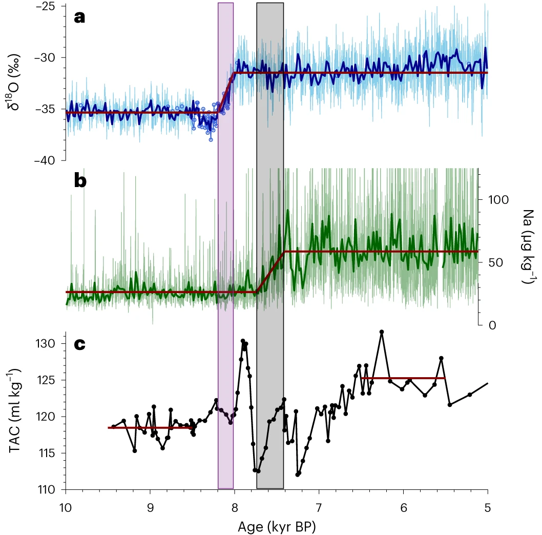
DOI https://doi.org/10.1038/s41561-024-01375-8 Abstract The extent of grounded ice and buttressing by the Ronne Ice Shelf, which provides resistance to the outflow of ice streams, moderate West Antarctic Ice Sheet stability. During the Last Glacial Maximum, the ice sheet advanced and was grounded near the Weddell Sea continental shelf break. The timing of subsequent ice sheet retreat and the relative roles of ice shelf buttressing and grounding line changes remain unresolved. Here we use an ice core record from grounded ice at Skytrain Ice Rise to constrain the timing and speed of early Holocene ice sheet retreat. Measured δ18O and total air content suggest that the surface elevation of Skytrain Ice Rise decreased by about 450 m between 8.2 and 8.0 kyr before 1950 CE (±0.13 kyr). We attribute this elevation change to dynamic thinning due to flow changes induced by the ungrounding of ice in the area. Ice core sodium concentrations suggest that the ice front … WeiterlesenAbrupt Holocene ice loss due to thinning and ungrounding in the Weddell Sea Embayment

One Thousand Centuries of Climatic Record from Camp Century on the Greenland Ice Sheet


Average near surface temperatures of the northern hemisphere during the past 11000 years (Dansgaard et al., 1969; Schonwiese 1995).

DOI http://dx.doi.org/10.1126/science.166.3903.377 Abstract A correlation of time with depth has been evaluated for the Camp Century, Greenland, 1390 meter deep ice core. Oxygen isotopes in approximately 1600 samples throughout the core have been analyzed. Long-term variations in the isotopic composition of the ice reflect the climatic changes during the past nearly 100,000 years. Climatic oscillations with periods of 120, 940, and 13,000 years are observed. W. Dansgaard et al., One Thousand Centuries of Climatic Record from Camp Century on the Greenland Ice Sheet. Science166, 377-381 (1969). DOI: 10.1126/science.166.3903.377

The catastrophic final flooding of Doggerland by the Storegga Slide tsunami


Weninger, Bernhard & Schulting, Rick & Bradtmöller, Marcel & Clare, Lee & Collard, Mark & Edinborough, Kevan & Hilpert, Johanna & Jöris, Olaf & Niekus, Marcel & Rohling, Eelco & Wagner, Bernd. (2008). The catastrophic final flooding of Doggerland by the Storegga Slide tsunami. Documenta Praehistorica XXXV. 34426126. 10.4312/dp.35.1.

DOI https://doi.org/10.4312/dp.35.1 Abstract Around 8200 calBP, large parts of the now submerged North Sea continental shelf (‘Doggerland’) were catastrophically flooded by the Storegga Slide tsunami, one of the largest tsunamis known for the Holocene, which was generated on the Norwegian coastal margin by a submarine landslide. In the present paper, we derive a precise calendric date for the Storegga Slide tsunami, use this date for reconstruction of contemporary coastlines in the North Sea in relation to rapidly rising sea-levels, and discuss the potential effects of the tsunami on the contemporaneous Mesolithic population. One main result of this study is an unexpectedly high tsunami impact assigned to the western regions of Jutland. Weninger, B., Schulting, R., Bradtmöller, M., Clare, L., Collard, M., Edinborough, K., Hilpert, J., Jöris, O., Niekus, M., Rohling, E. J., & Wagner, B. (2008). The catastrophic final flooding of Doggerland by the Storegga Slide tsunami. Documenta Praehistorica, 35, 1-24. https://doi.org/10.4312/dp.35.1

Germania magna – Ein neuer Blick auf eine alte Karte. Entzerrte geographische Daten des Ptolemaios für die antiken Orte zwischen Rhein und Weichsel.


Nüsse, Hans-Jörg & Marx, Christian & Lelgemann, Dieter. (2011). Germania magna - A new look at an old map: Rectifying Ptolemy's geographical data for ancient places between the Rhine and the Vistula. Germania. 89. 115-155. https://doi.org/10.11588/ger.2011.96480

DOI https://doi.org/10.11588/ger.2011.96480 Abstract This paper deals with the geographical indications for Germania magna in the Geographike Hyphegisis (ca. AD 150) of Claudius Ptolemaeus. Previous attempts at the identification of Ptolemaic locations were neither comprehensive nor based on a qualified analysis of the ancient data. By means of the geodetic-statistical analytic method presented here, an appropriate study of the Ptolemaic coordinates in conjunction with the identification of almost all Ptolemaic landmarks in Germania magna could be performed for the first time. The results of the investigation are presented and examined for their archaeological significance; the archaeological-historical information contained in the Germania-map is extracted. Nüsse, Hans-Jörg & Marx, Christian & Lelgemann, Dieter. (2011). Germania magna – A new look at an old map: Rectifying Ptolemy’s geographical data for ancient places between the Rhine and the Vistula. Germania. 89. 115-155. https://doi.org/10.11588/ger.2011.96480

x  Powerful Protection for WordPress, from Shield Security
Diese Website wird geschützt von
Shield Security